Welcome to the FishingMad article C-MAP Reveal Test and Review. In this article, I will walk you through what is C-MAP reveal, How it’s installed, Why I decided to use it, the benefits it provides, its cost, strengths, and weaknesses.
I love the technological advancements in marine electronics. In recent years I’ve invested much of my time to learn and understand the different features of my sounders. I think has really increased my catch rates on the water. Knowing when you use what function to help you navigate, locate fish and truly understand your surroundings. I recently purchased and installed 2 x Lowrance Elite FS 9 sounders. One for my Hobie Pro Angler 14 kayak and the other for my Quintrex 4.5 meter runabout boat. Now I’m already very familiar with Lowrance sounders after many years of usage with the existing Elite range, HDS Range, Hook Range, and even Simrads Units. Now, these units by default come with basic AUS/NZ Maps. These maps show you depth, routes, trials, basic contour mapping, waypoints, and markers on the water including ramps.
Please note we have a 35-minute video in our member’s area which walks you through all the different features of C-MAP Reveal which is found in our Sounder School Section.
BECOME A FISHINGMAD MEMBER & UNLOCK ACCESS TO

Workshops | Giveaways | Podcasts | Competitions | Reports | Maps | GPS Marks | Rigging Tutorials | Sounder School | Exclusive Footage | Tackle Talks | Gear Guides | Kayak Club | Much More

What is C-Map reveal
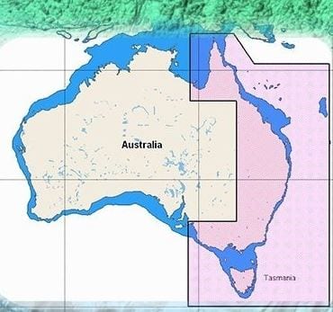
I started exploring C-Maps Reveal ( which was released in 2020 ) as I wanted to take mapping to the next level with technological advancements. I’ve always been envious of US fishing tournaments and seeing the level of detail they have across their bays, lakes, and estuaries with advanced resolution mapping. Therefore, I ordered and installed C-MAP Reveal. In particular, part number M-AU-Y010-MS preloaded with the eastern coastline Australian Maps specifically covering ( Tasmania, Vic, NSW, & Qld ). Now if you want to see this in action on your PC as an example then jump over to https://www.c-map.com/chartexplorer/
C-MAP Reveal Compatability
C-MAP is compatible with most Lowrance and Simrad sounders. You will want to double-check if you do have an old model Lowrance sounder against their website before buying.
( Compatible with Lowrance Ti2, HDS Gen2 & Touch 3, Carbon, Live – Simrad: Go, XSE/XSR, Evo2/3 ) Not compatible with Elite Ti, Hook/Hook 2, or Hook Reveal Series ).
C-MAP Reveal Cost
Having this advancement on your sounder is not cheap as C-MAP Reveal costs $449. Which comes in a small box with mapping data loaded onto an SD card that you insert into your sounder. I was curious to see how C-Map Reveal was against its competing rival Navionics which has set a high standard with its own mapping system and mobile Boating App. Considering Navionics Platinum with local Mapping on an SD card ( part number NPPC028R ) costs $379.
What do you get with C-MAP Reveal?

- You get an SD card pre-loaded with Maps that you insert into your sounder
- You get Shaded Relief on your maps ( to help you identify reefs, terrain, and structure )
- Depth Shading
- Advanced contour mapping
- Higher resolution Maps
- Satellite images which are a little like Google Earth
- Advanced routing
- More detail on harbors, ports, piers, and jetties
Installing C-MAP Reveal?
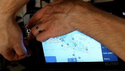
Now that the order arrived, I first Installed the C-Map reveal SD Card by simply lifting the rubber flap on the left-hand side ( Lowrance logo ) removing the micro SD card from the SD Card shell, and inserting it into the micro SD Card slot.
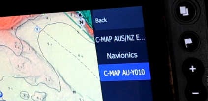
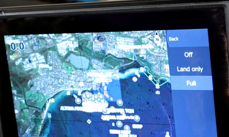
Several moments later a notification pop-up came on the screen asking if you would like to switch from basic AUS/NZ maps to C-MAP reveal Maps and of course, at this stage, we select yes. Don’t worry it’s very easy to turn this on and off by selecting Maps, Chart Options, and Source and switching between the basic maps, Navionics & C-Map Reveal.
C-MAP Reveal first thoughts
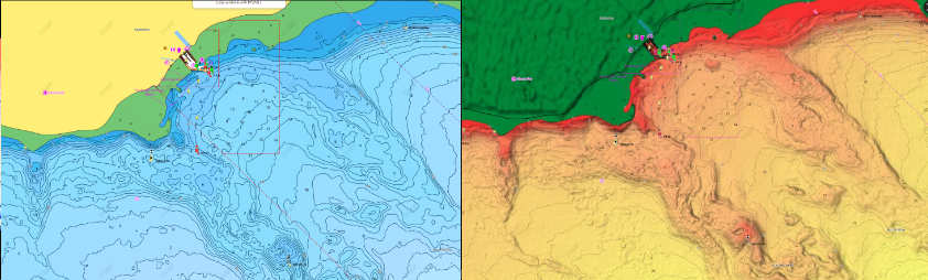
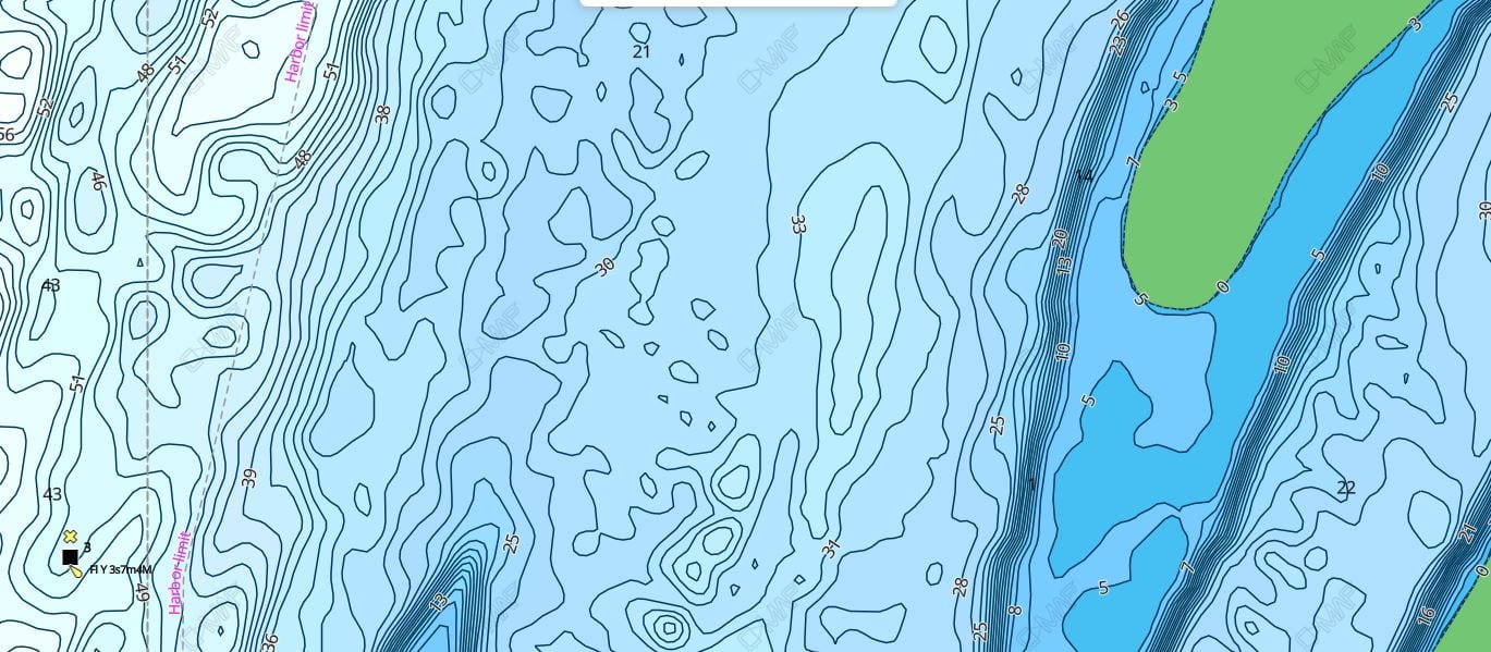
At this point, I started to enable features, particularly shaded relief which was the main reason why I wanted C-Map Reveal. I fish a lot on my kayak in shallow reefs that hold good volumes of snapper and salmon, and this improvement may be key to identifying reef edges. Immediately you see a massive difference, a huge improvement to the color scheme, the way to easily identify reefs, and the change of terrain. With confidence, I was now able to navigate around the edges of reefs and find pockets and dropoffs that you can’t identify with the default mapping.
The image below shows the default mapping view on the left vs the shaded relief view on the right using C-MAP reveal
Secondly, I turned on Hi resolution Bathy data which had 10x more contour mapping than the default maps. This was also very useful when fishing in areas with changing depths and terrains. Whilst fishing on my boat I was really able to hone in on dramatic contour changes, channels, run-offs and drop-offs, and changes to the terrain which was really helpful when finding great grounds to target gummy sharks and whiting.
Next, I started playing with satellite imagery and depth shading. Although these are nice features, I don’t think they played any role to improved catch rates. More nice have almost a gimmicky feature that looks really cool but you don’t use much of it. Now don’t get me wrong I can see where these features could be handy. The depth shading might be really helpful when fishing deep open waters like Portland fishing the shelf where your depth can change from 30 meters to 1.2 kilometers, but in the bay where I fish it didn’t provide much value. I would also say the satellite imagery didn’t provide a huge benefit as I thought it might and much of this was due to there being a very limited amount of local high-resolution imaging for lakes and estuaries.
C-MAP Reveal final thoughts after much testing
There are features that I really love about C-MAP Reveal and features that leave me wanting more. I really liked the Shaded Relief and would buy the product for that feature alone. Then I also liked the advanced contour mapping, increased routing, and satellite imagery even if it is a tad gimmicky. I did however feel like there were major issues with the resolution detail. Also a genuine lack of mapping for local lakes and estuaries ( which will likely get better in time ).
Because of these issues, I am torn as to whether at a cost of $449 it provides consumers with true value. There are certainly benefits here with increased mapping but at a steep price point.
C-Map Reveal Pros
- The Shaded Relief Technology was awesome and really helped me whilst fishing shallow reefs
- High resolution, Bathy data, or as we simple humans like to call advanced contour mapping was extremely helpful when fishing locations with dynamic depths and terrain. Really helping to find productive grounds for Gummy Sharks and Whiting
- Satellite imagery to have google earth views of surrounding areas
C-Map Reveal Cons
- Such a limited range of mapping is available for our local lakes. None of the Lakes and Estuaries I fish locally had any information which was really disappointing. It’s almost impossible to see a list of available lakes and estuaries. Now Navionics does advertise theirs even though their list is still quite limited. ( here is the list of local Navionics maps covering. Blue Rock Lake, Cairn Curran Reservoir, Eppalock, Hazelwood Pondage, Hopkins River, Hume, Lake Eildon, Lake Glenmaggie, Lake Wellington
Mulwala, Waranga Basin ) - The resolution and detail could be sharper
Thanks for reading C-MAP Reveal Test and Review. Feel free to check out our other Fishing Product reviews. if you have any questions or concerns then please let us know by contacting our team at enquiries@fishingmad.com.au cheers